There are trips you take to rest. Others to explore. And then there are those rare few you take to remember who you were before routine convinced you that was all there was. Peru isn’t a country you visit, it’s a territory that visits you. It follows you for months after you return, appearing in casual conversations, slipping into your dreams when you least expect it.
These seven places aren’t tourist destinations in the conventional sense. They’re laboratories of personal transformation disguised as landscapes. Some speak to you from the stillness of a mirror-like lake, others from the effort of a hike that redefines your limits. All of them, without exception, have something to teach you about the version of yourself that exists when you step out of your geographical and mental comfort zone.
Sacred Valley of the Incas
- Biking: 28-mile descent from Abra Málaga
- Hiking: Additional 9 miles toward Santa Teresa and Aguas Calientes
- Maximum altitude: Approximately 14,160 feet (Abra Málaga)
- Estimated cost: $220-$350 per person
- Duration: 3-4 days, depending on itinerary
- Activities included: Biking, rafting, zip-lining, and trekking
- Difficulty level: Intermediate, adventure sports oriented
- Permits: None required, only Machu Picchu entrance ticket
The Sacred Valley doesn’t owe its name to mysticism, but to the vital function it served during Inca times. Here, the Incas designed an agricultural system that still amazes visitors: terraces that continue producing, channels that need no maintenance, and towns that preserve their original names after five centuries of history.
Pisac, for example, has a market that’s over 500 years old, where trade happens in Quechua and they sell potato varieties you won’t find in any supermarket in the world. And Ollantaytambo deserves more than a quick visit. If you stay one night, you’ll see how the town recovers its rhythm when the tourists leave. Walking through its cobblestone streets at dusk, with the Urubamba River in the background, is a silent way to travel to the Inca past.
The Sacred Valley houses more than 600 varieties of potatoes, and the terraces of Moray concentrate up to 14 microclimates within a radius of just 1,640 feet. Additionally, due to its lower altitude than Cusco, it’s ideal for acclimatization: here you breathe easier and your body adapts more comfortably.
This place isn’t just a stretch toward Machu Picchu. It’s a complete destination, where history, land, and people continue speaking the same language they have for centuries.
Lake Titicaca
- Location: Border between Peru (Puno region) and Bolivia
- Altitude: 12,507 feet above sea level
- Area: Approximately 3,200 square miles
- Access: Flight Lima–Juliaca (1.5 hours) + transfer to Puno (1 hour), or direct bus from Cusco (6-8 hours)
- Recommended time: 2-3 days to include islands and overnight stays in communities
- Climate: Cold and dry, with mild days (59-64°F) and nights dropping to 32-41°F, even in summer
Titicaca isn’t just a high-altitude lake. It covers more than 3,200 square miles, equivalent to a European sea in the Andes, and exists because prehistoric geography elevated its course to nearly 13,000 feet of altitude. There, where oxygen is scarce, communities like the Uros, Aymaras, and Quechuas decided not just to resist, but to build civilization.
The floating islands of the Uros explain this best. Made of totora, a plant that grows on the same shore, these islands are literally worlds built by hand. Houses, boats, mattresses, and souvenirs emerge on a plant base that’s renewed every three months.

But Titicaca doesn’t end there. This lake is also a refuge for hundreds of bird and fish species that sustain dozens of lakeside towns. And for many, Titicaca is also an energy center. Its waters have been considered sacred since pre-Inca times, and even today there are those who come to meditate, make offerings, or simply seek clarity. Because yes, there’s something about the purity of the sky and the light bouncing off the water that changes the rhythm of your thoughts.
Inca Trail to Machu Picchu
- Location: Cusco Region
- Maximum altitude: 13,828 feet above sea level (Warmiwañusqa Pass)
- Total distance: 26 miles
- Average duration: 4 days / 3 nights
- Difficulty: Moderate to high
- Ideal season: April to October
- Access: Only with authorized operator; limited to 500 people/day
The Inca Trail is a route with stone paths traced by the Incas themselves more than 500 years ago. It connects valleys, mountains, cloud forests, jungle edges, and archaeological sites that can only be visited on this route and on foot. In essence, it’s a physical and logistical journey that requires preparation, respect, and planning.

The third day, although at lower altitude, involves continuous ups and downs. In return, it offers sites like Runkurakay, Sayacmarca, and Wiñay Wayna, where ruins peek out from cliffs. The last day begins at dawn and ends at the Sun Gate (Inti Punku), from where you see Machu Picchu for the first time, just as the sun illuminates it from the east. Upon arrival, you understand why it was worth it.
Machu Picchu
- Location: Cusco Region
- Altitude: 7,972 feet above sea level
- Main access: Train from Ollantaytambo (1.5 hours); bus from Aguas Calientes (25 minutes) or via Inca Trail or Hydroelectric route
- Climate: Humid temperate. Frequent rains from November to March, dry season from April to October
- Entry times: Staggered shifts from 6:00 AM to 2:00 PM
- Maximum stay: 4 hours
Machu Picchu is a victim of its global fame. It appears on bills, t-shirts, social media, and more. But if you go prepared, what you find isn’t just a famous ruin, but a masterpiece in operation. At 7,972 feet above sea level, on a ridge halfway up the mountain between Huayna Picchu and Machu Picchu Mountain, this citadel combines mastery with agriculture, astronomy, and urban planning like few in the world.
Built in the 15th century, probably during Pachacútec’s reign, its design responds to logic that still amazes: channels continue draining water, terraces prevent erosion, and each structure fits like a Lego piece, without cement, thanks to exact stone carving. Machu Picchu wasn’t completely finished, but that didn’t prevent it from surviving five centuries of weather, earthquakes, and oblivion.
The most common entry is by train from the town of Ollantaytambo to Aguas Calientes (the town closest to the Inca site), followed by a bus that climbs a zigzagging road. You can also walk up from town if you want extra effort before the visual impact. Ideal: enter first thing (6:00 AM) or last (1:00 or 2:00 PM), when there’s less congestion and more silence.
If you’re in good physical shape, book in advance the entry to Huayna Picchu or Machu Picchu Mountain. From those heights, everything makes sense. You don’t just see the Inca citadel from above: you understand the magnitude of the environment the Incas chose to build their legacy.
Vinicunca Rainbow Mountain
- Location: Cusco, Peru
- Altitude: 16,522 feet above sea level (viewpoint)
- Access: From Cusco in 3 hours by vehicle (via Pitumarca or Cusipata) + 2.8 miles of hiking (2 hours)
- Duration: Full day excursion (6-8 hours)
- Difficulty: Medium-high due to altitude, not distance
- Climate: Cold, strong wind, possible snowfall, best from April to October
- Recommendation: Acclimatize in Cusco or Sacred Valley at least 2 days before
Vinicunca Rainbow Mountain is the result of millions of years of sedimentation and tectonic movements. Its stripes of red, yellow, green, and pink come from minerals like iron oxide, sulfur, and copper. It’s said that until recently it was covered with snow. Only when the ice retreated did its colors emerge and turn it into an attraction.

The main obstacle isn’t distance, but altitude. The air contains about 40% less oxygen than at sea level. Therefore, if you’re not acclimatized, you may feel vertigo, dizziness, or shortness of breath. Many travelers rent horses for the final stretch, especially if their bodies are still adapting.
At the viewpoint, the complete visual display awaits you: the mountain with rusty red tones, green bands of minerals, white and ochre traces. Behind, Ausangate and its snowy glaciers reinforce the landscape’s impact.
Humantay Lake
- Location: Cusco, Peru
- Altitude: 13,780 feet above sea level
- Access: From Cusco, 3 hours by car to Soraypampa + 1.6 miles of uphill hiking
- Climate: High-altitude cold. Sunny mornings, afternoons with possibility of rain or hail
- Duration: Full day, leaving between 4:00 and 5:00 AM
Humantay Lake seems unreal when you see it for the first time. An intense turquoise color surrounded by glaciers, it doesn’t owe its fame to filters or retouching, but to its location at the foot of Humantay peak, in the heart of the Vilcabamba mountain range.

The effort is worth it. From the viewpoint, the lake unfolds in tones that change with the day’s light. Around it you see small apachetas: stone mounds placed by pilgrims as a sign of respect. There are no temples here, but there is a strong spiritual sense. The lake is seen as part of Humantay peak, a protective mountain deity. Visiting Humantay Lake is an encounter with one of the purest geographies of the Andes. At that altitude, the landscape doesn’t just impress, it also transforms.
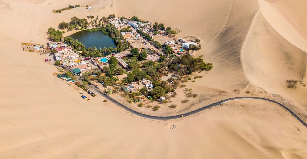
Huacachina Oasis
- Altitude: 1,332 feet above sea level
- Region: Ica, southern coast of Peru
- Distance from Lima: 190 miles (4.5 to 5 hours by car)
- Climate: Arid and sunny year-round (68°F to 90°F)
- Activities: Dune buggies, sandboarding, viewpoints, relaxing by the oasis
- Best time to arrive: 4:00 PM to see the sunset from the dunes
Huacachina isn’t just an oasis. It’s the only one in South America that remains active as a tourist destination, and it’s only five minutes by car from downtown Ica. Here you don’t come to see a lagoon from afar: you come to climb up, go down, scream, run, launch yourself on a board, or watch the sun set over the driest desert on the continent.
Dune buggy tours are the most sought after. They last between 1 and 2 hours, with stops at the highest dunes to launch yourself sandboarding. The guide accelerates as if there were no brakes, and that’s part of the plan. If you want adrenaline, this is the place. If you prefer something calmer, you can walk up to the viewpoint, have a beer facing the oasis, or sit and watch how the light changes tone every five minutes.

Your Trip to Peru, Without Complications
Traveling Peru on your own may seem simple, but it’s not. It requires booking ahead, knowing safe routes, acclimatizing well, and not improvising at altitude. What many sell as “adventure” ends up being chaos if you don’t plan it with criteria.
The Peruvian travel agency Waman Adventures doesn’t improvise. More than ten years refining every detail: local guides who know the way because they were born there, clear logistics, routes that adjust to your body and not the other way around. Machu Picchu, Humantay, Titicaca, Huacachina… the destination doesn’t matter if you do it with those who know what they’re doing.
Discover the best tours to Peru with Waman Adventures. Don’t let your trip depend on luck, let it depend on an agency that knows what it’s doing.